New data underscores relationship between development and urban heat
- Details
- Written by: Philippa Borland Penrith City Council (02) 4732 7777 (02) 4732 7958 council@penrithcity.nsw.gov.au https://www.penrithcity.nsw.gov.au 601 High St Penrith NSW 2750 Australia
Tuesday, 11 February 2020
Interim results from Council’s project with Western Sydney University (WSU) to collect heat data from 120 heat sensors over summer is already scientifically proving the relationship between development and urban heat.
According to Penrith Mayor, Ross Fowler OAM, the new data, which will be shared at the upcoming sold out Cooling the City Masterclass on 18 February (penrith.city/coolingthecity), tangibly reinforces how much sustainability decisions in development count in combating urban heat.
“You might say ‘why bother, because of course development affects heat!’ but it’s the type of development that really matters, and importantly the integrated planning of this with blue and green infrastructure,” said Cr Fowler.
“We know anecdotally there can be vast temperature differences across our region, but until now, we’ve lacked evidence to support and correlate this. Collecting heat data this summer will help scientifically inform decision making for our City and tackle rising urban heat. Importantly it also allows Council to advocate the business case to industry, the community and government, for doing things differently,” he added.
Heat sensors, recording results at ten minute intervals, were installed at ten varied locations across the Penrith local government area (LGA), collecting some 46,000 temperature measurements.
The five-week measurement period started on 12 December and included 4 January 2020, when Penrith’s temperature soared to a staggering 48.9 degrees.
According to WSU’s Dr Sebastian Pfautsch, who is leading the study for Council, the results captured on that day revealed a 3.6-degree difference between Tench Reserve (on the Nepean river) and suburban St Marys.
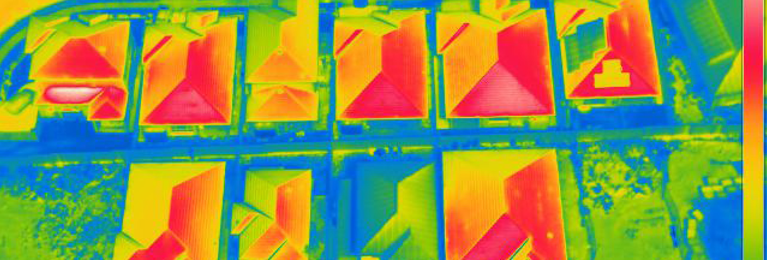
“Tench Reserve was a relatively cooler 45.2 degrees on that record breaking day, while St Marys reached 48.8 degrees. The difference between the two places is, one is dominated by green and blue infrastructure, while the other has a high proportion of hard urban surfaces,” he explained.
Dr Pfautsch said that the integration of green infrastructure with buildings is vital to provide a liveable climate in a hot place like Western Sydney as it grows.
“Without trees, summer heat becomes unbearable. In new housing estates where you have small blocks almost completely covered by houses with black roofs, it means there is simply no space to grow a meaningful canopy,” he explained.
“We therefore need to urgently rethink how we plan, build and live, to make more room for greencover and start using smarter solutions like cool roof technology now in the homes and businesses we build,” added Dr Pfautsch.
The interim heat sensor results also showed that the coolest temperatures recorded were in the South of Penrith’s LGA, in Mulgoa and Badgery’s Creek.
According to Dr Pfautsch this means that planning and the very judicious use of urban materials in that area, is crucial to avoid locking Western Sydney into inescapably high future urban heat.
“The process of developing Western Sydney contributes massively to urban heat. And we know how much growth is planned in this area, particularly with the new Western Sydney Airport and associated Aerotropolis precinct,” said Dr Pfautsch.
“Unless we execute this with considerations for urban heat at the very forefront of our planning, 50-degree-plus summers will unfortunately become Western Sydney’s reality. The heat difference already measured on 4 January 2020, between Tench Reserve and St Mary’s, is just a precursor of what lies ahead for Penrith,” he added.
Along with other expert presenters, Dr Pfautsch will discuss his interim findings at Council’s Cooling the City Masterclass at The Joan Sutherland Performing Arts Centre on 18 February. This sold-out event for built environment professionals will champion the case for more sustainable development in Western Sydney.
The full results from Council’s heat sensor project with WSU, with data collated from 120 sensors throughout Penrith’s LGA across summer, will be available mid 2020.
Image: Urban heatmap of Western Sydney rooftops, c. Dr Sebastian Pfautsch
Information contained within this news release was correct as at Tuesday, 11 February 2020.